© Nova Fisher www.novatravels.net
South Coast of Iceland
Click on any photo to see a slideshow of larger versions
Reykjanes Peninsula
4 x 4 off road adventure
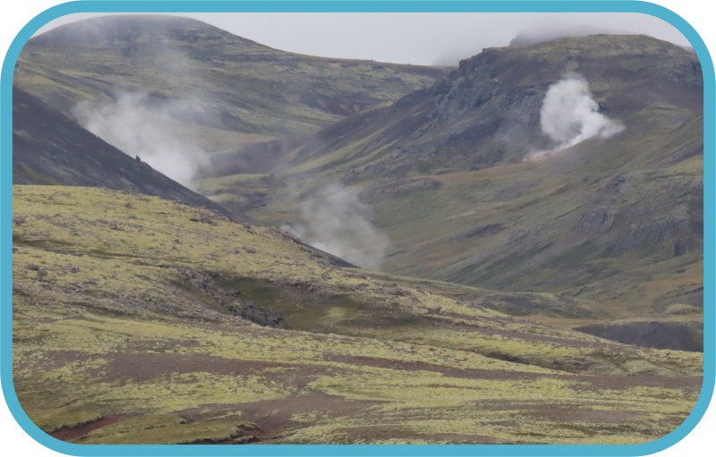
We went on two trips to the Reykjanes Peninsula in the south of Iceland. The first trip was an unforgettable, sometimes scary 4 x 4 off road adventure. We experienced the true ruggedness and natural beauty of the area, despite the rainy conditions. We drove through the lava fields and hot water plants then headed off the beaten track on The Thousand Waters trail, which winds its way through numerous rivers, mud banks, and streams. In the quaint village of Stokkseyri, we paused for lunch at Fjöruborðið, a restaurant renowned for its Icelandic langoustine dishes. They were delicious. After lunch, we had a quick stop at Grænavatn, a crater filled with vivid blueish green water, The name translates to ‘Green Lake’. The lake is dyed a seafoam green due to the amount of sulphur in it, as well as its depth of 45 metres (148 ft). The closer to the centre, the more intense the green. Our next stop was the charming Strandarkirkja Church on the coast. We continued on the multicoloured deposits caused by the hot springs of Krýsuvík, We took a short walk among the boiling mud pools, hot springs and hissing steam vents. There are walkways so you can safely cross the uneven earth to the different features of the area, and there are many signs that have been erected to explain the geothermal and geological forces at work. The reason for so much geothermal activity here is because of Iceland’s tectonic plates. Our next stop, Lake Kleifarvatn, is one of the deepest in Iceland at 97 metres. The lake has diminished since year 2000 because of two major earthquakes, which probably opened up fissures at its bottom. In the southernmost part a hot water from some hot springs runs into the lake but elsewhere the lake is very cold. Sadly it was raining heavily so we couldn’t see the stunning scenery and the tuff-rock mountains reflecting in the water. We ended with a pleasant drive through the charming town of Hafnarfjörður, situated on an ancient lava flow.Waterfalls, Glaciers and Volcanic beaches
On this day we drove through agricultural land and geothermal areas we passed through Hveragardoi, Selfoss and Stokkseyri en route to our most southerly fishing village of Vik.. Unfortunately, it rained most of the day. Our first stop was the old houses of Drangshlio. These turf houses and old farmhouses are built into an enormous freestanding rock, in front of the Eyjafjöll Mountains. Local farmers would keep their stock in these houses, and legend has it they were also once home to elves. Onward to Skogafoss Waterfall which is one of the most iconic waterfalls in the country with a 60m drop and was featured in Game of Thrones. We walked up to the top of the waterfall. After a short drive, we stopped at Reynisfjara black sand beach, near the town of Vik. The beach was once rated by National Geographic as one of the 10 most beautiful non-tropical beaches in the world. The cliffs are basalt columns. Offshore are the Reynisdrangar rock formations which are four rocky sea stacks. They were featured in Season 7 of Game of Thrones in a few scenes shot ‘North of the Wall’. After leaving Vik we went to Sólheimajökull, an outlet glacier coming down the fourth biggest glacier of Iceland, called Mýrdalsjökull. Besides waterfalls, Iceland is also known for glaciers. 11% of the country is covered by ice. Heading back in the direction of Reykjavik, we stopped at Seljalandsfoss waterfall. The waterfall lays underneath the well known Eyfjallajokull, the volcano that erupted in 2010. It is possible to take a walk behind the waterfall’s curtain. Our final waterfall stop was at Gluggafoss or Window Falls. The river has formed tunnels and grooves through the soft rock which have carved a series of windows in the tunnels, hence the name. At the river passes under a stone rock. At Bessastadir, the official residence of the President, we visited the remote Bessastadir church which the President attends every Sunday. Our final stop was an old red volcanic lava area.
The Mid-Atlantic Rift
The Mid-Atlantic Rift runs all the way through Iceland; the western part of the country, including Reykjavík, the Snӕfellsnes Peninsula and the Westfjords, are all on the North American tectonic plate, while the east, including the East Fjords and Vatnajökull National Park, are on the Eurasian plate. This rift runs right across the Reykjanes Peninsula, and has dramatic consequences on the landscapes. As these plates pull apart, magma is brought close to the surface of the earth, causing groundwater to boil and create geothermal areas. Krýsuvík, in fact, is not the only geothermal area on the peninsula; there is another called Gunnuhver, and a hot spring beneath the lake of Kleifarvatn. These plates pulling apart make the Reykjanes Peninsula susceptible to earthquakes. It is also lined with cone-shaped volcanoes, and coated in lava rock, revealing a long volcanic history.
Hveragerdi
Hveragerði sits on a highly geothermal area. Boiling water runs just beneath the surface of the ground, leading to many hot springs in the nearby hills. This is both a blessing for the town and a curse. In terms of a blessing, it allows greenhouses to flourish, as they can be provided with heat throughout the year. Hveragerði is thus the world’s northernmost producer of bananas, which are grown alongside a host of other fruits and vegetables. Many flowers and herbs are also grown here, and it is considered the centre of botany in Iceland. The boiling water also allows food to be cooked simply by burying it for a few hours, providing the restaurants in the area with unique menus. It also brings the area a wealth of tourism. The curse of this geothermal water is the effect it has on the residents. Stories of hot springs opening overnight in people’s kitchens, bedrooms and living rooms are very common.