
The Canaries & Madeira

A Spanish archipelago off the North West coast of Africa plus Madeira

Click on any photo to see a slideshow of larger versions
Tenerife
Tenerife is the largest and most
developed of the Canary islands
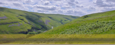
Dominating the entire island is snow-capped volcano Pico del Teide, Spain’s tallest peak and the third largest in the world, measured from the ocean floor. It is criss-crossed with some of the most spectacular hiking trails in the Canary Islands. Bananas are the main crop as they grow all year round due to the even climate. Each plant requires 26 litres of water, which is desalinated water. A highlight in the calendar is the Carnival of Santa Cruz in February, the biggest parade after Rio de Janeiro. Unfortunately, we left the day of the carnival. One of the Canary Islands’ most futuristic buildings is by the harbour – the Auditorio de Tenerife. At the more historic end of the scale is the Basilica of Candelaria, dedicated to the patron saint of the Canary Islands. For four nights we stayed in Los Gigantes (The Giants), a resort town on the west coast of Tenerife. Its main feature is the giant rock formations that rise from the sea to a height of 500-800 metres (1,640–2,625 ft) after which the town has been named. They are among the highest cliffs in Europe. These cliffs are in full view of our hotel. It is one of the most beautiful areas of Tenerife as you get the best the island has to offer: spectacular vistas, a unique natural setting, a warm climate, black beaches, great hikes but (almost) no party scene. The marina has lots of restaurants and shops selling whale and dolphin watching boat trips.Mount Teide, Masca, Garachico and Icod
de la Vines
We drove through the small town of Vilaflor which, at 1400m has the highest vineyards in the world. They grow 40 different types of grapes. Often you have to drive through the low cloud to reach Mount Teide but we were lucky that there was no cloud. At 800m the landscape is pine forest which survivie on the northern winds from Europe. The pine trees take water from the clouds through their leaves and we were told they are resilient to fire. At 1200m there are warmer trade winds so papaya and avocados are grown. At 2000, there are very few plants as the cloud stops at 1800m. We finally reached Mount Teide. Located in the centre of the island it is the highest peak in Spain, with an altitude of 3,715 metres (12188 feet). If measured from the ocean floor, its height of 7,500 m (24,600 ft) making Teide the third-highest volcano in the world. (There is a cable car that will take you up to 3,555 metres, although to reach the crater you need a permit and to be in shape, because the last section has to be done on foot.) The last eruption of Mount Teide was 1909. We stopped off at the Roques de Garcia, the former summit of the island, which gave us great views of the Rocks, the peaks known as The Cathedral and Mount Teide. Regarded as emblematic of Tenerife, Roque Cinchado is a 27-metre high rock pillar, composed mostly of volcaniclastic sedimentary rock layers. We drove down a scary single track road, descending 850m to Masca which is a remote villageat 600m at the top of a ravine. There are 26 inhabitants who maintaine their beautiful houses, colourful vegetation and cobbled streets. It has been declared an Ethnographic Historic Place of Interest, which is reflected in the Masca Ethnographic Museum. The village is surrounded by sweeping hills with a ravine down to the sea. The ravine is currently only open to experienced hikers at weekends. We travelled ‘over the ridge’from the south area to the north area where the weather can often be 21C in the south and a cloudy 13C in the north. They often have 1m of rain in this area but we were lucky to have full sunshine all day. Our next stop was Garachico, a town named after the offshore rock. It was the richest town in the 15th Century as it was the trading port between America and Europe. The town took a 6% fee for all passing trade. Most of the town was destroyed by a volcanic eruption in 1706 when Montaña Negra erupted, spewing out rivers of lava that swept through the town to destroy its golden goose, the harbour. Only the church and part of the fort survived. Our final stop was Icod de los Vines which is a very quaint village. Here we saw the oldest Dragon Tree at 800 year, 17m high and a crown of 20m diameter. The dragon tree is not a tree but a plant which is a cross between a tree and a cactus. It is named because the original settlers thought they has arrived on the edge of the world and looked to Greek mythology to see that a dragon was their protector. On our return to Los Gigantes we drove through the pine woods near San Jose de los Llanos where there were several hiking trails.


Landscapes

Nostrud ad nisi ut esse sint eu deserunt ut dolor ipsum

© Lorem ipsum dolor sit Nulla in mollit pariatur in, est ut dolor eu
eiusmod lorem